Learning to Drive on Central Ave. in Humarock

It must have been 1940. I was coming up to 6 years old. On Saturdays, late afternoon, Dad would drive his old Chevy to Steads store to get a bottle of Ballantine Ale and a cigar. I would beg him to drive to Fourth Cliff. We would drive over the hump in the old wooden bridge, pass Dick Smith’s garage, and make a left on Central Ave. Stopping near the Humarock Lodge, I would climb into his lap so I could steer and shift.

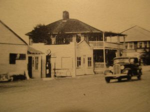
Dick Smiths Garage & Residence, Corner of  Marshfield Ave. & Central Ave., Humarock. c.mid 30s.

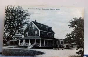
                                                      Humarock Lodge. c. mid 1930’s.

Dad taught me how to shift the 3-on-the-floor. Dad would operate the clutch and gas; I would steer & shift.

“Okay, into first,” he would say. Away we went.

“Okay, into second.” We went faster!

“Okay, into third’.” We were flying! Maybe 30 miles an hour past Hatches boat yard.

We turned at the base of Fourth Cliff and returned to the Lodge. I would take my place in the passenger side, then urge my Dad to go fast over the hump in the bridge — which he did. All the wheels flew into the air! Or at least that’s what I thought. No, we didn’t tell Mom ’til years later.

During the war years, there were fewer trips to the Cliff because of travel restrictions. Dad worked for the Boston Record American Newspaper and had a news reporter pass, so we were let through the barricade, and no, he wasn’t a reporter. Dad did not allow me to drive in Humarock during those times.

After the war, I could drive without sitting in Dad’s lap, so off to Humarock for a drive out to the Cliff, or south Humarock to Carl Moreheart’s parking lot next to Rexhame Beach.


W. Ray Freden, Marshfield/Seaview 70 Years.

Some Memories of Going to Humarock

From a very early age, I remember my Mom pulling my wagon to Humarock from our home in Seaview, to visit with her sister Margie. My Dad attached a box onto the wagon and I fit inside. It was a long bumpy ride. The roads were not paved as smooth as they are today (later in my youth, I was always frustrated trying to roller skate on the rough Seaview streets).

As we came over the knoll on Sea Street, Humarock came into view with the old wooden bridge to cross. During one of these trips across the bridge, my wagon wheel slipped down in between the boards, and my Mom couldn’t pull it out. She had me get out and we tugged at it — to no avail. I was pretty scared and in tears. My Mom took hold of me and across the bridge we went, leaving my wagon behind. She knew where help would be.

Into the Humarock Garage we went, to ask her friend Dick Smith, the owner, for help. He said, “Sure, Ruthie.” He came out with a pry bar and off we went back to the wagon. One pry and out it came. My wagon was saved!

Mr. Smith told my Mom not to use the wagon, with its narrow wheels, on the sidewalk — to use the roadway instead, because the boards went the other way and so the wheels would not get stuck.

Mr. Smith, Mom, & I in my wagon were now off the sidewalk and on our way to visit with my aunt Marge. I don’t remember any of the visit, but I do remember the trip back across the bridge. We now were in the roadway, past the hump, and almost off, when a car came along and the driver hollered at us to get off the roadway and onto the sidewalk! My Mom hollered back at him and told him to go-somewhere! There was quite a bit of talk — about that person — at the supper table that night with Mom & Dad. Mom knew who the driver was that hollered at us, but she never told Dad.

WWII Radar Station on Holly Hill

During World War II, probably in 1943, the Corps of Engineers and private contractors built a radar station on Holly Hill between Buttonwood and Holly Roads, 150 feet above sea level. It was called 112-A, site 1A. The SCR 296A was a standard World War II fire control radar utilized by the U.S. Coast Artillery for engaging surface targets. The function of the radar was, during periods of poor visibility, to provide the range and azimuth of the target vessel to the plotting room of the battery. The six inch battery, #204, was located on Fourth Cliff.

Communication was by underground cable. The cable extended down Holly Road to Elm Street, over Ferry Hill, under Ireland Road, to the South River; then under the river to Central Ave. and on up to the Gun Battery. The cable was about 2.5 inches in diameter, containing a number of copper wires wrapped with insulation and steel covering.

My friend Tom once dug up some of the cable in his front yard on Dwight Road. I witnessed a large portion of it dug up under Ireland Road when the town was doing a drainage project. I’m sure plenty more is waiting to be discovered.

The land for the tower was leased from Ernest Dragon of Upland Road and Laura Dwight, possibly of the Doctor Dwight family that lived in a huge mansion at the end of what is now Christmas Tree Lane.

On the site was a concrete building that housed a 2 kw gas generator, and another building that housed a standby generator. A 1000-gallon gasoline tank serviced the generator. A freestanding 114-foot tower that housed the radar antenna was disguised as a water tower. This was located next to a 21’x21′ cement block radar transmitter building. A chain link fence with barbed wire on top surrounded the operation.

The SCR 296-A was declared obsolete in January 1946. The tower and equipment were to be disposed of, the buildings to be retained. The barbed wire didn’t prevent two young teens from scaling the fence and climbing the ladder to the top of the tower. The view was spectacular!

Radar on Holly Hill, disguised as a water tower. 
Photo taken by Larry Bonney.